Terrestrial LiDAR (Light Detection and Ranging) for 3D imaging has matured tremendously in the last decade, thanks to consumer (mobile phones and computers) and automotive safety and autonomy applications. Over 70 companies are vying for a portion of this $billion market. In the meantime, the technology has progressed for drone and higher altitude aerial 3D imaging for defense and commercial mapping (forest, urban, real estate). Sylvera has developed a LiDAR-machine learning platform that bridges terrestrial, aerial and satellite LiDAR data to map forests for biomass and carbon content, enabling more transparent trading of carbon credits in commodity markets.
Commercial space-based 3D LiDAR imaging has yet to emerge in a big way. Nuview, an Orlando, Florida-based company, aims to disrupt this market. It recently emerged from stealth mode to address the nascent space-based LiDAR mapping market and announced a $12M Series A funding round led by MaC Venture Capital. Leonardo DiCaprio, an angel investor in companies that focus on sustainability and the environment, is one of the investors in this round.
Terrestrial LiDAR data is generated either on fixed or moving platforms (cars, ground robots, people) and addresses shorter ranges (< 1 km). The LiDAR units are lower cost, less demanding in optical and electrical power requirements, and provide superior spatial and depth resolution. However, the data is more expensive to acquire in terms of mapped area/hour and challenging to scale over large areas. Drone and aerial LiDAR are more scaleable and efficient (higher mapped area/hour). However, spatial and depth resolution is poorer, and more expensive LiDARs are needed to image at longer ranges (5-10 km). Satellite-based LiDAR solves the scalability problem and ensures data freshness (orbital trajectories and satellite constellations allow periodic measurements of the same geographical area enabling comparisons of vegetation, infrastructure, climate, wind and rain patterns, etc. over time). However, such satellites are typically in Low Earth Orbit (LEO) and require LiDAR ranges of ~400 km, requiring very high power lasers and sensitive detectors, as well as on-board data storage and transmission. Consequently, it requires large and expensive satellites.
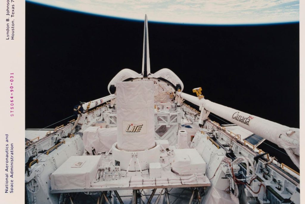
Space-based LiDAR has existed for over 50 years, with NASA first deploying the LITE (Light In-Space Technology Experiment) mission for earth observation three decades ago (Figure 2). It was launched as the principal payload on the Discovery space shuttle in 1994 and gave researchers a new way of looking at Earth’s atmosphere from space (3D vs 2D). The experience was invaluable and provided the background and justification for successive space-based LiDAR imaging missions like the Cloud-Aerosol Lidar and Infrared Pathfinder Satellite Observation (CALIPSO), the two Ice, Cloud and land Elevation satellites (ICESat and ICESat-2), Global Ecosystem Dynamics Investigation (GEDI), and the Cloud-Aerosol Transport Systems (CATS). These are typically expensive missions, run as part of government programs with specific goals (agriculture, climate, weather prediction, etc.)
LiDAR as a space-based payload has been slow to launch for two reasons:
1) The high SWaP (Size, Weight and Power) and costs associated with these systems. Nuview aims to leverage the increasing maturity of terrestrial and aerial LiDAR in developing low-cost, low SWaP satellite-mounted LiDAR.
2) The prohibitive costs and time frames of constructing and launching payloads and satellites. Traditionally, space has been the domain of a handful of global space powers, and space missions have been run primarily by government space agencies for covert and scientific purposes. Mission launch costs are high, payloads are bulky and expensive, and time frames from funding to launch are long (5-10 years). This has changed in the past decade with the advent of well-funded commercial space players (Amazon, Virgin, SpaceX, etc.) and a vibrant venture-funded ecosystem focused on satellite and payload launches for tourism, manufacturing, communications, mapping and space services. Costs and time-frames associated with the manufacture and launch of satellites and payloads have been reduced dramatically. The commercial space economy has grown from ~$175B in 2007 to ~$425B in 2022, comprised of infrastructure, space products and space services.
NuView plans to launch a network of twenty satellites with proprietary LiDAR payloads to map the Earth annually. This constellation would be in LEO and require an imaging range of 400 km. Clint Graumann is the CEO of NuView. With a background in remote sensing, his goal is to ”“revolutionize the Earth observation industry by building the first commercial satellites designed to annually map the planet’s entire land surface with LiDAR.” The proprietary flash LiDAR design uses lasers in the ~1 um wavelength and an array of SPADs (Single Photon Sensitive Detectors). The depth resolution is < 1 m (tens of centimeters), and the angular resolution is ~1.5 m. Onboard processing and compression algorithms minimize data storage and transmission overhead.
A prototype proof of concept satellite (”Mr. Spoc”) is under construction and will be launched within 24-36 months. The launch will be designed to create a manually decaying orbit to ensure space sustainability and eliminate any space debris pollution. Based on the learnings from the Mr. Spoc launch, Nuview intends to launch commercial satellites sequentially in batches of five until a constellation size of 20 satellites is achieved.
Mr. Grauman indicates that only 5% of the Earth’s surface is currently LiDAR-mapped. The data Nuview intends to acquire presents several business opportunities ranging from forest mapping, disaster prevention (floods, fires, etc.), infrastructure planning, insurance tech, etc. The company has ~$1B in contingent purchase orders for such data products (contingent on the successful launch of the satellite constellation with LiDAR payloads).
Building LiDAR for terrestrial mapping was difficult a decade ago, but the autonomous car revolution has matured the technology tremendously. Making a low SWaP, low-cost LiDAR for sustainable space mapping is a different level of complexity. It will be interesting to see how Nuview rises to this challenge.
Read the full article here


