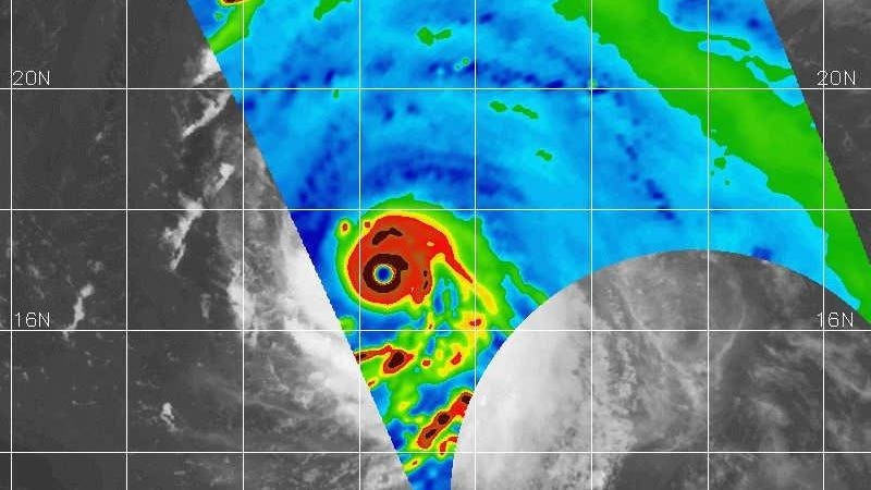
Hurricane Lee has a rather common name, but it is far from a common storm. At the time of writing, Hurricane Lee is a powerful and rare Category 5 hurricane in the Atlantic basin. Mike Fisher, a colleague at the University of Miami and the NOAA Hurricane Research Division, called the image above one of the most impressive that he has seen in NASA satellite-based microwave imagery. Like other colleagues, I have been stunned by several aspects of the storm. It has a textbook structure and has become a meteorological monster. Here are three reasons why Hurricane Lee is stunning meteorologists, and what you need to know about it.
The Rarity of Category 5 Status
A Category 5 storm on the Saffir-Simpson scale is a rare event. It is a tropical system with sustained winds that can exceed 157 mph. How rare you might ask? According to Brian McNoldy, a hurricane expert at the University of Miami, roughly 4 percent of named storms in the Atlantic basin have reached that threshold since the early 1920s. There has been a slight uptick over the past decade.
WPLG meteorologist Michael Lowry provides further context on the rarity of the storm. On the social media platform X, he posted, “Hurricane #Lee is in elite company tonight. Fewer than 1% of all tropical cyclone “fixes” ever attain Category 5 strength.” Lowry’s post also points out a unique geographical aspect of Hurricane Lee. It is the farthest southeast that a Category 5 hurricane has been observed in the Atlantic basin during the 172 year recordkeeping era.
The Rapid Intensification
Hurricane Lee became a powerful storm very quickly. In recent years, I have been using the term “rapid intensification” more frequently and that is worrisome. Rapid intensification is defined as a tropical cyclone wind speed increasing by 35 mph or more in less than a day. Here’s the jaw-dropping fact about Hurricane Lee. It’s sustained winds intensified by 80 mph within a day. As a scientist, I am inclined to call that “hyper intensification.” Phil Klotzbach is a hurricane expert at Colorado State University. He notes that Lee becomes only the seventh hurricane in the satellite era to intensify by 80 mph or more in twenty-four hours. The other six storms have all been within the past twenty years.
At one point, a Hurricane Hunter aircraft dropsonde, a device released from an airplane within storms to take meteorological measurements, measured maximum sustained winds near 160 mph and a minimum central pressure close to 927 mb. Other reports since then have indicated possibly higher winds. As I write this Friday morning, there are slight that dry air may be interacting with the storm. It is also possible that an eyewall replacement cycle could happen at some point. When one eye contracts and a larger one forms, as we saw with Hurricane Idalia at landfall, there could be some drop off in intensity.
However, I fully expect a Category 4-5 level storm for some time to come. The National Hurricane Center discussion on Friday morning revealed, “Since Lee is expected to remain in favorable atmospheric conditions while moving over even warmer waters during the next couple of days, it seems likely that the hurricane will at least maintain its intensity or become a little stronger during that time.” They also mentioned the possiblity of eyewall replacement cycles, which can be challenging to pinpoint but affect storm strength. Thankfully, most track forecasts keep Hurricane Lee out to sea. However, the upper East Coasts of the U.S. and Canada, respectively, need to continue monitoring the storm. Some model runs have it perilously close to Cape Code by next weekend. Additionally, a storm of this intensity could create oceanic swells and rip current issues up and down the East Coast.
Kieran Bhatia, a tropical weather expert and Vice President at Guy Carpenter, says Hurricane Lee may be in the top .04% of all twenty-four hour intensity changes in the Atlantic. Extremely hot water is certainly one of the drivers of this rapid intensification. It is the high octane fuel for these massive heat engines. Eric Blake of the National Hurricane Center provided important context on sea surface temperatures earlier in the week. He presented a hypothetica scenario for Hurricane Lee in 1983 water temperatures versus today. Though previous hurricanes in the basin brought cooler water to the surface, Brian McNoldy reminds us that there is plenty of warm sea surface temperatures for such explosive intensification.
The Boldness of the National Hurricane Center Forecast
Another “wow” factor with this storm is just how aggressive the National Hurricane Center was with its early intensity forecasts. Unfortunately, they are gaining more experience with rapidly intensifying storms. Additionally, high-resolution hurricane models are improving, and more robust observations (from aircraft, satellites, etc.) are being ingested into them. On the social media platform X, DTN Weather’s lead forecast engineer Sam Lillo said, “The sample size gets ridiculously small up here, but… Lee is a category 5 hurricane with maximum winds of 140kts, with a NHC official forecast to hit 155kts … which is the highest 12-hour forecast for any storm that wasn’t already at least 150kt.” Also, check out below what Andy Hazleton posted earlier in the week. Unfortunately, nature is giving meteorologists an extreme workout in recent years, but at least our forecasting capability seems up to the task.
Read the full article here


